
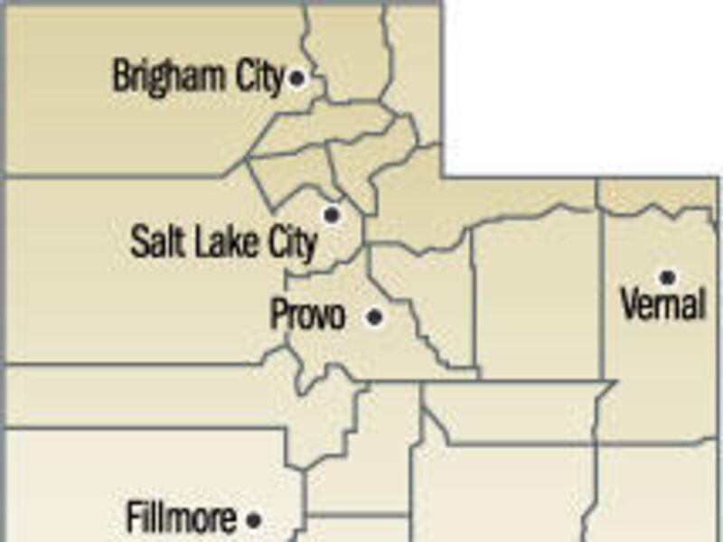


The nice thing about Utah is that so many of its natural wonders can be shared, as is the example in Garfield County.
Within the boundaries are parts of Grand Staircase-Escalante National Monument, Glen Canyon Recreation Area, Capitol Reef National Park and Canyonlands National Park, not to mention a good share of the Boulder Mountains.
What you know:
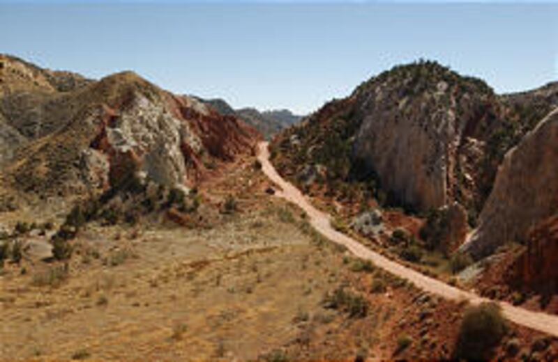
Highway 12 is probably Utah's most famous stretch of highway.
The highway, from start to finish, all 120 miles, is breathtaking. There is a blend of natural attractions seldom seen anywhere, let alone over such a short stretch of road. It is considered one of the top 10 Scenic Byways in the country. It starts with Red Canyon a few miles from the turnoff near Panguitch and ends with a ride over the Boulder Mountains.
Past Red Canyon there are Bryce Canyon National Park, Mossy Cave, Kodachrome Basin State Park, Escalante Petrified Forest State Park, Calf Creek Falls Recreation Area, the Escalante Canyons, and the Anasazi Indian Village State Park. There are the towns of Tropic, Cannonville, Henrieville, Escalante and Boulder, quaint farming communities with small stores and down-home restaurants and not a single stoplight among them.
There are streams and lakes, hiking and biking paths, and attractions dating from pre-man to modern cowboys and Indians. And there's more yet to be discovered.
It's easy looking at a map to see why so many people consider Garfield County a true "natural" treasure.
The eastern border of the county is the very path of the Colorado River as it flows into Lake Powell and on down to the Halls Crossing area, forming a pretty jagged but definitive border.
Along that line, and in the center of the river, is a section of Cataract Canyon, Utah's most famous and well-traveled whitewater river adventure.
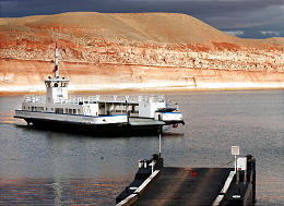
The remainder of the border incorporates the upper half of Lake Powell, from Halls Crossing to Hite. It is one of the lesser-visited areas of the lake. Most visitors opt to stay in and around the Bullfrog area or venture south on into Wahweap.
Many who visit this area, however, consider the upper reaches some of the most spectacular on the lake.
Seven-Mile Canyon, about 24 miles uplake from Bullfrog, with its striking rock walls and contrasting colors, is said to be one of the most photographed of the 96 major canyons on the lake.
The Grand Staircase-Escalante National Monument, the nation's newest protected area, is far and away the largest protected area covering roughly 1.7 million acres of sandstone cliffs of varying hues and wilderness.
A presidential proclamation set up Grand Staircase-Escalante National Monument in 1996. Only now are people starting to discover some of the fascinating features in the monument.
Only a small corner of Canyonlands fits within the county. Close to the border and accessible by a rugged, four-wheel road that heads into the park off Highway 95 near Hite, is Teapot Canyon. The roads, as such, end at Waterhole Flat, to the south. The canyon trail is a little beyond Teapot Rock, which leads into the Land of Standing Rocks, the Maze and the Doll House. The area is remote, seldom visited and very different from other areas of Canyonlands.
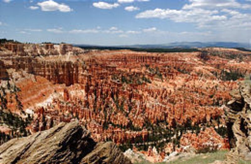
Bryce Canyon National Park is located in the southwestern part of the country and is Utah's second most popular national park next to Zion.
Rising from its red rock and soil are thousands of naturally-carved figures, called "hoodoos," that take on forms and figures of a thousand places, things, animals and people.
In truth, even though it goes by the name "Canyon," Bryce is really the easternmost escarpment of the Paunsaguant Plateau. Visitors have the option of taking the 37-mile round-trip drive through the park or taking one of many hikes offered, the most popular being to Sunset and Sunrise points (the striking pink and red and orange colors given off by the land and hoodoos is at sunset and sunrise), Rainbow, Yovimpa and Inspiration Point.
Inside the park are 50 miles of hiking trails and a paved road to a number of overlooks into country so special it was saved from ever being changed by an act of Congress.
At the entrance to the park is Ruby's Inn, which offers full services, including ATV and horseback rentals, guided trips and, of course, accommodations and meals.
Kodachrome Basin, long considered one of the state's most picturesque parks, offers a nice campground, a number of hiking trails, wagon and horseback rides and biking trails.
But, what people see from the camping area is only about half the park. There's a lot more there than what people think.
Marked trails over the gentle terrain lead to a number of nature-carved spires, including the often-photographed Ballerina Spire, White Buffalo, Big Bear and Mama Bear. The shortest hike is a 1/4-mile nature trail and the longest is a 5-mile loop to Big Bear Geyser.
Southeast of Kodachrome Basin is Grosvenor Arch, another of nature's natural carvings in a solid-rock mountain.
The Petrified Forest, adjacent to Wide Hollow Reservoir, dates back some 150 million years when big trees and dinosaurs used the land. Once buried, these trees, and some dinosaur parts, are resurfacing.
Here, too, are campsites, complemented by the reservoir, and a number of hiking trails starting within the park. The one trail to the petrified wood is about 1 mile long, and after a steep climb to the plateau, levels out into a gentle, educational walk.
The latest addition is a short nature trail with a large number of examples of the wood-turned-to-rock. To make the trail, none of the wood was disturbed in the park.
There are a variety of activities, from water skiing to hiking, the latter being one of the biggest attractions.
Past the town of Escalante, and just before climbing to the scenic Escalante overlook and highway, is Calf Creek Recreation Area. It's a refreshing 3-mile hike to the lower falls and a day hike to the upper falls. The trail along the stream winds through a maze of canyons and river-bottom country.
A short distance farther on is the ancient Anasazi Museum and State Park, which dates back 750 and 900 years ago. It is one of the largest known villages of early residents. Peak population was around 200 people.
Thus far they've uncovered about 83 rooms, about 50 of them being habitation or living quarters, and hundreds of early living conveniences, such as bowls, sandals and arrowheads.
To show more of the life and conditions back then, there is a museum and auditorium that offers early-American history lessons.
Boulder Mountains, with the rounded mountain tops of pines and aspens and hidden lakes, offers visitors an aerial view of southern Utah's rocky, maze-like landscape.
What you don't know:
While other national parks in Utah, like Bryce and Zion, get all the attention, sometimes lost is Capitol Reef National Park, which was set aside first as a national monument in 1937 and later, in 1971, as a national park.
It is, by size, almost twice as big as Bryce and Zion (378 square miles) and offers a lot of things the other parks don't.
Because of the camping and conveniences, most of the visitors tour the section of park to the north of Highway 24. Some of the more remote and spectacular features are to the south, in the area located in Garfield County, which would include Waterpocket Fold, a unique geological creation.
There are a number of beautiful hikes in the park. There are maps and books in the visitors center giving details of 25 hikes, some that are less than a mile and some upward of 25 miles. This is arid country and hikers need to be prepared before setting out with all the right clothing, shoes and water.
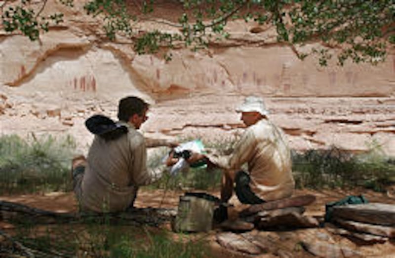
The park also has a wealth of petroglyphs left by the early Fremont and Puebloan or Anasazi Indians.
There are a lot of artists located within the county, ranging from jewelry makers to drum makers.
Visitors can find a number of slot canyons in the county. Two of the most popular are Peak-a-boo and Spooky Gulch. They are about a mile apart. Popular with many people is to hike up one, cross over and hike down the second.
The canyons are very narrow in places and the walls reach up hundreds of feet and, at times, block out the sun.
This is an area rich in very early history, too. Paleontologists searching near Cannonville found remains of a hadrosaur (duckbill dinosaur) whose skull is on display at the Utah Museum of Natural History.
It is one of the best dinosaur skeletons ever discovered in southern Utah's Grand Staircase-Escalante National Monument. Counting the skull, the hadrosaur is estimated to be 70 percent complete. Also found were sections of what are being called "very well-preserved skin impressions around the hips and tail."
It is said that there is only one other place in the world, China, where good skin impressions of dinosaurs have been found. There are also a lot of dinosaur tracks found in the area.
Hiking, biking and ATV trails are yet another feature of Garfield County. Popular trails include the Cassidy Trail and the Casto Canyon Trail.
The Cassidy Trail is 8.9 miles. The trail winds through scenic red rock country and majestic ponderosa pine. Sections of the trail are believed to have been used by Butch Cassidy, the famous outlaw.
The Casto Trail is 5.5 miles long and takes hikers and bikers into a collection of hoodoos and cliffs of white, pink and green.
There are, in fact, a number of popular trails listed on the county's Web site.
Then there are the fishing opportunities, which range from the many lakes in the Boulders to the Sevier River to Panguitch Lake.
Garfield County is, indeed, a place where those in search of the "natural" things will want to visit.
Garfield County
Well known: Lake Powell, Boulder Mountains
Unknown: Spooky Gulch, ATV trails
Contact: 435-676-1160 or www.brycecanyoncountry.com
Next week: Sanpete County
E-mail: grass@desnews.com