


LAYTON — The four best S's of summer hiking — solitude, serenity, shade and scenery — are all readily available on what has to be one of the premier hikes in all of Davis County — Adams Canyon.
If you are physically able, you're not a true Davis County resident, and especially not a "Laytonite," if you haven't hiked Adams Canyon — a four-star outdoor experience.
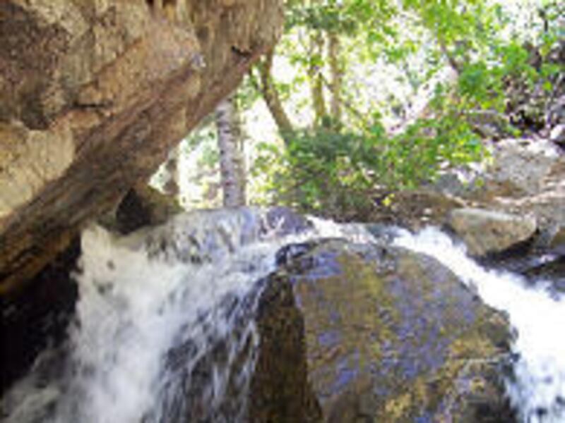
Not only is this a perfect canyon hike in the heat of summer, but there's a spectacular and refreshing 50-foot waterfall — complete with wading pool — at the trail's end, too.
"I like all the shade and the trees," said Katherine Day of Layton while hiking Adams Canyon earlier this year.
Her hiking companion, Michelle Dalton, also of Layton, was equally complimentary.
Dalton said the waterfall at the end of the hike is an excellent bonus.
"It's also a good place to meet people, too," she said.
Indeed, on a typical summer day, more than a dozen cars will be sitting in the dirt parking lot at the trailhead. But don't be surprised when you don't see that many people up Adams Canyon. That's because this trailhead also connects with the Bonneville Shoreline Trail, and usually half of the people parked at the trailhead are along that path instead.
"It's just a beautiful little hike," said Barry Burton, assistant community development director of Davis County.
He estimates that Adams Canyon is probably the second most popular hike in Davis County, behind Bountiful's Mueller Park path.
Burton said he also likes the shade on the Adams trail. "There are nice trees all around you," he said.
Enjoying the refreshing mist of the waterfall on a hot summer day is also great, and Burton stressed you don't need to hike all the way to the falls — all of the trail is a great hiking experience.
He said K Achter, a landowner and resident near the mouth of Adams Canyon, donated land some years ago to help create today's trailhead, thus avoiding private-land issues. He also donated a vital piece of property in that area that connects to the Bonneville Shoreline Trail.
A trek up Adams Canyon to the waterfall — four miles round trip —will require a minimum of two hours for the fastest of walkers and an average of three hours for most people.
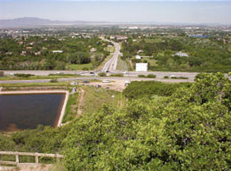
But hikers just 20 minutes to the mouth of the canyon will enjoy an excellent bird's-eye view of north Davis County. Those walking into the canyon will be treated to shade and scenery, as most of the trail follows Holmes Creek.
This isn't an easy hike because the trail passes by some rugged rock outcropping and has several steep slopes in the upper reaches of the canyon. Young children need supervision in the upper canyon.
Some regular runners have also been known to trot up the canyon, at least half way.
One stream crossing is required two miles up the canyon. Although there was no bridge in May, a makeshift wooden-plank bridge was added in June.
Hikers who go all the way to the waterfall will get wet as some wading is required.
Total elevation gain along the canyon to the waterfall is about 1,400 feet — with the steepest portions in the initial switchbacks of the first half-mile of the trail.
Just after the trail enters Adams Canyon proper and gets into thick shade, watch for a right fork in the path. This leads across a sturdy wooden bridge and is access to the south portion of the Bonneville Shoreline Trail. (The north part of the trail junctions off to the left before the main trail enters the canyon.) Do not turn there unless you want the Shoreline path.
Jim Olsen, an avid Utah hiker, has a Web site, utahhikes.net. He hiked Adams last month and reported on his site:
"We wanted to see the falls at high water, and this spring seemed especially good for that. There was indeed more water than I have seen before. . . Someone has put in a new bridge crossing about half way up the trail, about 30 feet down stream from the old one. The new one clears the water better, and you won't get wet. At the top we had to wade in the stream to see the falls, but it wasn't bad since the stream is quite wide there and not very deep."
Directions to reach the trailhead: The trailhead is east of U.S. 89 and Oak Hills Drive junction in east Layton (about 700 North). Access the frontage road on the first or second road that heads east off U.S. 89 going north from Oak Hills. Park on the pavement of the frontage road or in a dirt area that is just west of and below a reservoir.
Trail description: Rock and dirt, with plenty of loose sand in the first half-mile. Don't let the early steepness discourage you. The trail is much more moderate after the first half-mile. Stay on the trail to avoid erosion problems.
Cautions: The trail is near some private land and homes in the first half-mile, so proper respect should be given. The newer foothill trail purposely swings north to avoid private land.
Beware of bicycles. Mountain bikers use the first half-mile of trail to access the Bonneville Shoreline Trail.
Children will need supervision crossing a rocky outcropping two-thirds of the way up the canyon. Shortly thereafter, an eroded hillside along the stream can also be tricky. As such, some choose to walk in the stream to avoid these cliffs. (Some may choose to turn back when reaching these obstacles.)
Portions of the upper trail may be difficult to follow. Several sections include side paths. If you get lost, or find yourself on rocky ledges, backtrack to a trail junction and look for an alternate path.
Take care when hiking above the waterfall. It is easier to go up this steep rocky slope than it is to descend. The trail above the waterfall fades out in a half-mile.
Burton said most the rescues in the canyon have been from those hiking above the waterfall.
Because of the shaded areas, recent rainfall can make upper portions of this trail unusually muddy.
Dogs should be kept on a leash to keep them away from other hikers and help them avoid a face-to-face encounter with rattlesnakes, which are occasionally seen halfway up the canyon but will quickly retreat when given the chance.
Although some hike Adams Canyon alone, it is never wise to hike solo.
Also, carry plenty of water and do not drink the stream waterr.
Season of use: Adams Canyon is usually hikeable without snow from April to October.
Tidbits: The canyon is named for Elias Adams, a pioneer who settled at its mouth and built a sawmill. The stream's namesake is Samuel Holmes, a trapper who was living near there when the pioneers arrived in 1849.
Several landmarks along the trail are: 1. A huge pine tree, about a mile up the trail; 2. A large boulder in the stream, 1.5 miles up the trail that creates its own waterfall and which some call, "refrigerator rock."
Camping: Three primitive camping spots are available, though these aren't sanctioned Forest Service areas. The first is just past the mouth of the canyon and the second is across the creek at the 1.5-mile mark. The third is two miles out, just across the wooden bridge. Fire restrictions may apply to Adams Canyon each year in late summer.
E-mail: lynn@desnews.com