


SALT LAKE CITY — Federal and state highway officials Thursday released an environmental analysis identifying the route for the proposed 19-mile West Davis Corridor designed to serve commuters in western Davis and Weber counties.
The route from Farmington to West Point would connect with I-15 and Legacy Parkway at Glovers Lane on the south end, and at state Route 37, or 1800 North, at approximately 4000 West on the north end.
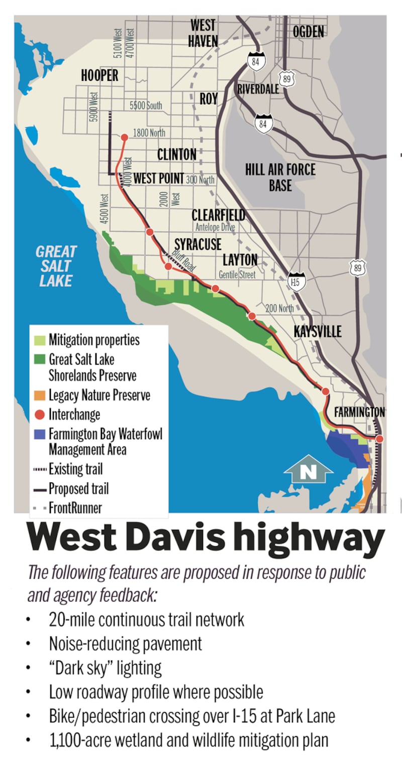
West Davis Corridor | Heather Tuttle
The Federal Highway Administration and the Utah Department of Transportation have been working on the final draft environmental impact statement the past seven years, developing and analyzing 51 alternatives that were under review by a study team.
Input from residents, farmers, community and environmental groups, cities, counties, and federal and state resource groups was considered in determining the final route, transportation officials said.
"After years of detailed analysis, collaboration and extensive public outreach, together we've identified a transportation solution that will benefit western Davis and Weber counties for many years to come," said UDOT project manager Randy Jefferies.
The planned corridor includes "dark sky" lighting and noise-reducing pavement, Jefferies said. Lighting would only be placed at on- and off-ramps and be directed downward to the pavement, and the highway would be constructed with its height at the lowest level possible along much of its route to minimize impacts to surrounding communities.
"We are making every attempt to keep the height of the road as low as we can, and by doing so make it less intrusive to communities," Jefferies said.
Transportation officials said the number of households in western Weber and Davis counties is projected to increase by more than 65 percent by 2040, and Davis County is the second-most densely populated county in the state.
They estimate the West Davis Corridor will reduce traffic congestion west of I-15 by 35 percent in the area.
"There is serious congestion on I-15 and on those east-west routes in western Weber and Davis counties," Jefferies said. "It will only get worse."
The proposed corridor will require the demolition of up to 34 homes. UDOT officials said they will work with homeowners to compensate them for their property at fair market value and help them with relocation.
"We want to make sure the homeowners are treated fairly and relocated to a place they desire and are made whole," Jefferies said.
The proposed route identified in the analysis has the least impacts to protected agricultural areas — 3 acres.
"We have been working with farmers in the area and made alignment shifts to minimize impacts to farms," Jefferies said.
Ron Gibson, president of the Utah Farm Bureau Federation, said western Weber and Davis counties boast a unique microclimate on the eastern shore of the Great Salt Lake, with rich soils and temperatures that are moderated by the lake.
The areas are some of the first in Utah to be used for farming, so it was important in the planning process for the West Davis Corridor to minimize impacts to the area's agricultural heritage.
Construction of the corridor, which could begin as early as 2020, also comes with a wetlands and wildlife mitigation plan involving the preservation of 1,100 acres of wildlands to offset ecosystem impacts.
Because the corridor cuts into a portion of the Great Salt Lake Shorelands Preserve managed by The Nature Conservancy and abuts a good section of its eastern boundary, highway officials worked with the group, the U.S. Army Corps of Engineers and the U.S. Fish & Wildlife Service to develop a mitigation plan.
Jefferies said the route identified in the analysis has the least amount of impacts to residents, farms, communities, wildlife and wetlands, but a new thoroughfare will still come with societal and ecological effects.
"This will be a great benefit to transportation in northern Utah for many years to come," he said. "At the same time, we are very aware this impacts people; this impacts lives. We have tried very hard to minimize impacts, not only to the lives of our citizens, but to lives of our wildlife and our precious ecosystem."
The route also comes with a new 20-mile bike trail that connects with the Legacy Parkway path to encourage bicycle commuters.
The public can weigh in on the environmental analysis over the next 30 days. The final document is available at UDOT's West Davis Corridor webpage, as well as in hard copy form at city hall buildings and libraries throughout the study area.
Comments can be submitted through Aug. 31 online, via email at westdavis@utah.gov or by mail at 466 N. 900 West, Kaysville, UT 84037.