

The National Oceanic and Atmospheric Administration is best known for its scientific research on oceans, weather and climate, but the agency’s network of low-earth orbiting satellites sometimes also plays a critical role in responding to emergency situations.
On Monday, NOAA released a report detailing how its satellites helped coordinate emergency operations that led to the rescue of 397 people from potentially life-threatening situations throughout the U.S. and its surrounding waters in 2022.
NOAA says its polar-orbiting and geostationary satellites are part of the global Search and Rescue Satellite Aided Tracking system, or COSPAS-SARSAT, which uses a network of U.S. and international spacecraft to detect and locate distress signals sent from emergency beacons on aircraft, boats and handheld personal locator beacons anywhere in the world.
Since 1982, COSPAS-SARSAT has been credited with supporting more than 50,000 rescues worldwide, including more than 10,100 in the U.S. and its surrounding waters.
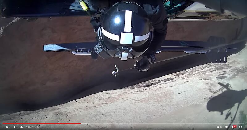
And last year, one of the emergency responses coordinated by NOAA satellites led to the rescue of 17 people from a treacherous slot canyon in Utah’s Garfield County. In 2022, Utah ranked third in the country for states with the most rescues coordinated by NOAA’s satellite network, trailing Florida, which had 106, and Alaska with 56.
When a NOAA satellite pinpoints the location of a distress signal in the U.S., the information is relayed to the SARSAT Mission Control Center at NOAA’s Satellite Operations Facility in Suitland, Maryland, according to the agency. From there, the information is sent quickly to Rescue Coordination Centers, operated either by the U.S. Air Force for land rescues or the U.S. Coast Guard for water rescues. NOAA also supports rescues globally by relaying distress signal information to international SARSAT partners.
“The value of NOAA satellites goes well beyond forecasting,” Steve Volz, assistant administrator for NOAA’s Satellite and Information Service, said in the report. “The life-saving ability of SARSAT is a credit to the teamwork with the U.S. Coast Guard, the U.S. Air Force, NASA and our international partners.”
On June 10, 2022, 15 boys and two adults who were part of a youth group from The Church of Jesus Christ of Latter-day Saints were hoisted to safety after they were stranded on a ridge in Sandthrax Canyon in Utah. According to NOAA, the Air Force Rescue Coordination Center received the alert from a personal locator beacon and notified the Garfield County Sheriff’s Office, which launched a Utah Department of Public Safety helicopter to the coordinates where the distressed hikers were located.
Garfield County Sheriff Danny Perkins said the public safety helicopter, deputies and rope rescue personnel responded to the area, which is “one of (the) most treacherous slot canyons in Garfield County”, according to a report on the incident from KSL-TV.
Other 2022 emergencies in which NOAA satellites played a role in U.S. rescue operations include:
- On Nov. 20, seven people were rescued from a commercial plane after it was forced to land on a frozen lake near Bethel, Alaska, as a result of engine failure. The Alaska Rescue Coordination Center, which obtained the coordinates of the downed plane, alerted another aircraft company, which made the rescue.
- On Aug. 5, a U.S. Coast Guard helicopter pulled a sailor to safety from his capsized boat off the coast of New Smyrna Beach, Florida. The sailor grabbed the life raft and activated his beacon before his boat sank.