

- Downgraded from Category 5 to 2, Hurricane Erin is causing severe conditions off the East Coast of the U.S.
- Puerto Rico and Virgin Islands received up to 8 inches of rain, experiencing widespread power outages.
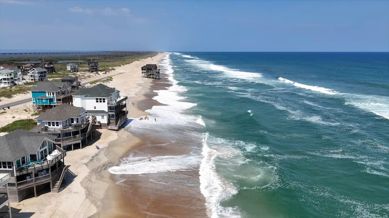
- North Carolina's Outer Banks are expected to face severe impacts, prompting Gov. Josh Stein to declare a state of emergency.
After reaching Category 5 over the weekend, Hurricane Erin is now down to Category 2, but the large hurricane is still causing problems off the East Coast of the U.S.
The hurricane is sending life-threatening currents and dangerous surf along the coast and is expected to produce destructive waves and storm surge in North Carolina.
Erin’s sustained winds are just shy of Category 3 status. Though it is not forecast to make landfall, it will still impact much of the East Coast as it travels north, nearly parallel to land, per CNN.
The storm first formed from a tropical wave on Aug. 11, and by Aug. 15, it had become a hurricane and “quickly joined the ranks of the fastest intensifying hurricanes in Atlantic history, increasing its winds by 85 mph in about 21 hours,” per USA Today.
It spared some islands along the eastern Caribbean, but Puerto Rico, the Virgin Islands and portions of the southeastern Bahamas were soaked, with up to 8 inches of rain. The winds caused power outages in both Puerto Rico and the Virgin Islands.
The threat from Erin stretches up and down the entire East Coast — beaches as far north as Massachusetts have been closed to swimmers due to rough surf. The rip current risks are expected to last through most of the week.
According to NPR, on Tuesday morning, the hurricane was around 690 miles south-southeast of Cape Hatteras, North Carolina. It was moving northwest at 9 mph with maximum sustained winds of 105 mph.
The storm is still expected to grow as it travels.
Rough conditions expected in North Carolina’s Outer Banks
The worst impacts from Erin are expected on Wednesday, and in order to prepare for that, North Carolina Gov. Josh Stein declared a state of emergency on Tuesday.
According to USA Today, the winds from Hurricane Erin could push up to 4 feet of storm surge onto North Carolina’s Outer Banks on Wednesday and Thursday. A storm surge warning is in effect for the area.
The Outer Banks is also expected to see extensive beach erosion, with waves over 20 feet forecast through the week. According to CNN, the waves will likely cause severe coastal and beach damage.
North Carolina’s Dare and Hyde counties, which encompass much of the Outer Banks, have issued mandatory evacuations for Hatteras and Ocracoke islands.
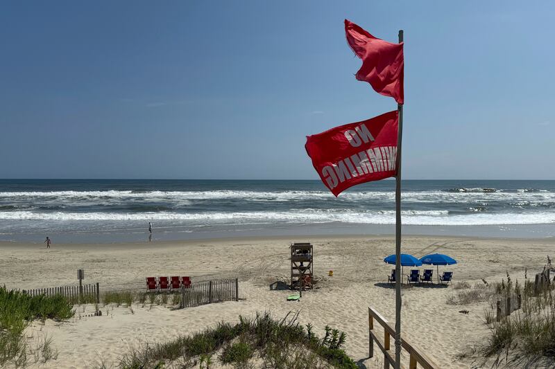
Dozens of swimmers rescued in North Carolina
So far, scores of swimmers have already had to be rescued from the rough conditions created by the hurricane.
At North Carolina’s Wrightsville Beach, over 70 rescues were conducted, and the beach has issued a no-swim advisory through Friday, per CNN. In nearby Surf City, there were 15 rescues made.
A person was also rescued from rip currents at a South Carolina beach on Monday as multiple states have issued no-swim decrees until the threat from Hurricane Erin passes, per USA Today.
Forecasters monitoring potential tropical storms
While Hurricane Erin is the current concern of meteorologists, it’s not the only concern.
Forecasters are also monitoring two other tropical systems in the Atlantic, per USA Today. One is in the central part of the ocean and the other is off the coast of Africa. Both systems are being monitored as to whether they could develop into a named storm. The next named storm will be called Fernand.
So far, neither of the monitored disturbances appear to be a threat to land.
This year’s hurricane season began on June 1 and has not yet reached its midpoint, so there is plenty more activity expected before it ends at the end of November, per USA Today.