
If you skip a rock across the surface of the Great Salt Lake, it will skim and ricochet across the far-reaching, glassy face for what seems like a mile. It’s as if the waters were never introduced to the laws of gravity. Or if they were, it didn’t matter. The lake’s salinity — and in turn, its density — has increased since the mid-1800s. Today, the tourmaline-colored water in the north arm is eight times saltier than the ocean. Rocks, those daring enough to swim and reflections of flushed sunsets are held at the surface of the water — suspended and unable to be lost. But in a cruel illustration of irony, we are losing those waters. As historian Dale Morgan put it in 1947, “It is a lake of paradoxes.” Today, the Great Salt Lake’s volume has dropped nearly 50%. The largest saline lake in the Western Hemisphere is drying up.

It’s not a singular case, nor a surprise, to some keeping track of the water of the world. The Dead Sea in Jordan, the Aral Sea in Kazakhstan, the Salton Sea and Owens Lake in California, Lake Poopó in Bolivia, Lake Urmia in Iran — they are all disappearing (or have disappeared) at rates faster than anyone anticipated. One study from the National Audubon Society found that out of nine Western saline lakes, more than half have withered by 50% to 95% from their earliest recorded levels to present.
The Great Salt Lake’s size has always fluctuated. According to the United States Geological Survey, its surface area has varied from about 3,300 square miles at its highest levels in 1986-1987, to about 950 square miles at its lowest level in 1963. But over the course of more than a century of documentation, researchers have been able to account for an 11-foot drop in lake levels due to human development, which has occurred mostly over the past 10 years. That might not sound like a lot when you think of most lakes, but the Great Salt Lake is not like others. Its lakebed is shallow — averaging a depth of just 15 feet and recording a maximum depth of about 33 feet. When water levels drop, more shoreline is exposed than what would be exposed in deeper bodies of water. What’s left behind is a dusty playa full of toxic chemicals and hazardous pollutants. According to research from Utah State University, nearly 50% of the lakebed is now exposed. Approved water developments that are currently underway could take the water level down another 10 feet. This time, it may not be part of the cycle. It may be the end.
Long before the arrival of John C. Frémont — the first white explorer to describe the Great Salt Lake — the entire Great Basin region was a sprawling freshwater inland ocean known today as Lake Bonneville. What scientists believe to be an event of sudden erosion on the northern shoreline an estimated 16,800 years ago led to Lake Bonneville draining by way of a yearlong flood that swept into what is now southeastern Idaho. What was left behind of the prehistoric lake were fluctuating wetlands, endorheic lakes — which are lakes contained within a basin and have no outlet — and playas. And what became of all that was the Great Salt Lake.
According to research from USU, Indigenous tribes moved into the oasis-like basin near the lake’s shores more than 10,000 years ago. Eventually, this led to Shoshone and Utes tribes at the north part of the lake, and the Goshute tribes at the south end of the lake. In the latter half of the 19th century, Frémont observed the Indigenous peoples’ simple symbiotic relationships with the complicated environment — like eating brine fly larvae — and recorded them. He also observed the large benches beyond the southern shores and deemed them to be former shorelines of a larger and deeper lake. He was right. Frémont’s detailed journals and early recordings served as inspiration to white settlers desiring to come west — including one particular group of pioneers.

In 1847, Brigham Young and early Latter-day Saint pioneers arrived at the Great Salt Lake. According to Bonnie Baxter, director of the Great Salt Lake Institute, the group immediately noted the parallel geography of the Salt Lake Valley and the Holy Land in the Middle East, each with salt and freshwater lakes joined by a river. This was, to some, affirmation that Utah was a place for their “chosen people, just as the Holy Land was seen as the promised land for the Lord’s people in another time.” Only a few hours later, the Mormon pioneers were tilling to plant crops and swimming in the briny waters. “We cannot sink in this water. We roll and float on the surface like a dry log. I think the Salt Lake is one of the wonders of the world,” Orson Pratt, a member of Young’s initial pioneer company, journaled.
“At twilight, a wild and thrilling spectacle. ... Dim and pale, the moon, the ghost of a dead world, lifted above the distant Wasatch peaks and stared at the acrid waters of a dead sea.” - Alfred Lambourne, 1909
Soon enough, the Salt Lake settlement had grown into Salt Lake City, and commerce, travel and industry were foisted upon the namesake water. Construction on the Lucin Cutoff, a 102-mile railroad line that included a 12-mile railroad trestle that traversed the Great Salt Lake, began in 1902. Five passenger trains and seven freight trains chugged across the Lucin Cutoff in each direction daily by 1908 — seemingly floating above the salty waters as they passed from Ogden, past Promontory Point, and onward to the Nevada state line.
In the late 1800s and early 1900s came the resorts. Three have been called “Saltair” and stood on the southern shores. They were meant to be respites for dancing and courting, where trusted members of the community and youngsters alike could have fun without worry of gossip, according to Stephen Carr, a lifelong Utahn and co-author of “Utah Ghost Rails.” Trains left Salt Lake City every 45 minutes to head toward what investors hoped would be the Coney Island of the West, roller coaster and all. But the ill-fated Saltair burnt down in 1925. The second Saltair — which was built in 1926 — boasted the world’s largest dance floor at the time and featured a boat that took swimmers to and from the resort when water was low. But it fell victim to the Great Depression, motion pictures, World War II and yet another fire. Today, the third Saltair is a specter of a concert venue, looming beside Interstate 80 and decaying pilings that once supported the pier. Other resorts at the lake suffered similar fates much earlier in the timeline. The Garfield Beach Resort was founded by Capt. Thomas Douris in 1881. Patrons traveled to the resort via steamboats named General Garfield, Susie Riter and the Whirlwind. But Garfield Beach Resort too burnt down in 1904.

With resorts singed into a memory, the most persistent presence on the shores of the lake — like so much of the West — became extractive industry. And the most prominent businesses that came to life on America’s Dead Sea were (and still are) brine shrimp harvesting, mineral extraction that produces various salts and cyst harvesting. Brine shrimp produce eggs, which are called cysts, that happen to be a very nutritious and well-liked food for commercially raised fish and shrimp. So these cysts are harvested and used as food in the aquaculture sector. Altogether, these three markets account for about 7,000 jobs and $1.3 billion in revenue in the Salt Lake Valley today. Mineral extraction ponds frame the lakeshore, looking like the remnants of a giant’s forgotten stained glass windows.
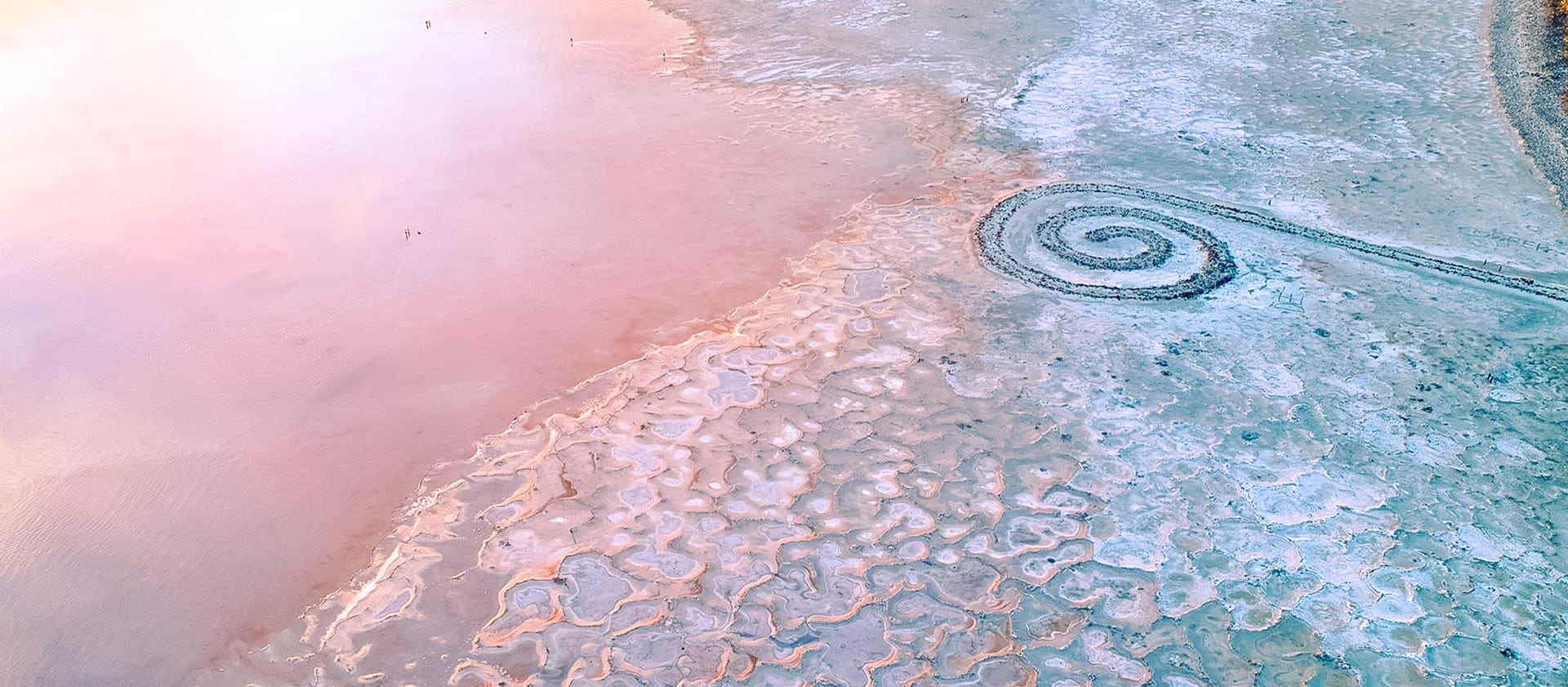
In the 1950s, the trestle railway was replaced with the rock-filled causeway that is still present today. This causeway allowed rail transportation to continue, with freights loaded with brine shrimp, cysts and minerals. But it was built like an ancient wall, and the causeway bisected the lake — effectively creating a human-made north lake and south lake. The freshwater tributaries flowed into the southern arm, but only a fraction of freshwater made it to the northern arm. The two bodies of water became increasingly disparate and the high salinity and faster evaporation of the southern arm made it less and less hospitable for the brine shrimp population, too dense for mineral mining, and created an especially toxic type of mercury called methylmercury. The threat was visible. A bird’s-eye view of the causeway would grant one an unsettling — if not captivating — look at a pink, otherworldly body of water mirrored by its green twin.

Human-made problems came, followed by human-made solutions, followed now by more, even bigger problems. People augmented an entirely new lake than what was left behind by Lake Bonneville. The amount of water going into the lake has not remained constant. Even with an impressively large snowpack and, in turn, runoff season in 2017, it was not enough to bring the lake up to its historical average elevation of 4,200 feet. Four seasons later in March 2021, the lake is back resting at 4,192 feet. Thanks to a compounding cycle of drought and water diversion, the lake’s water levels are a game of two steps forward and three steps back.
After near-record low precipitation in 2020 and 2021, Utah water supplies remain in dire straits. This winter’s snowpack local watershed stood at 65% of average in Big Cottonwood Canyon’s Brighton and 87% in Parleys Canyon — two of the six areas home to watershed-contributing streams in the area — in early March.
Due to prolonged droughts throughout the year, most of this spring’s runoff is going to be guzzled up by a thirsty ground instead of in the Great Salt Lake’s three major tributaries: the Jordan River, Weber River and Bear River — where most diversions in the Wasatch Front come from. Reservoirs across the state are low, currently sitting at 66% of capacity. The state’s largest reservoir, Lake Powell, is grimly hovering around 40% capacity. But a study published by Utah researchers in the journal Nature Geoscience found during water-budget analyses that drought and climate change are not the determining factors of our alarming water circumstances.
Utah public supply customers use the most water per capita in the U.S. “In Utah we use 150-200 gallons per day per person,” Sarah Null, associate professor of watershed studies at Utah State University, said during a March seminar. “When you compare Utah water use to other arid climates, we dwarf others in water use.” Now we’re seeing municipal five-stage water shortage contingency plans go into place — asking residents of the Wasatch Front to only run washing machines when they are full, flushing the toilet less, shortening shower times and cutting back on watering lawns in hopes of keeping water in the watershed without imposing mandatory cutbacks. But research from the Utah Division of Water Resources states that municipal and industrial water use accounts for only 11% of water use in the Wasatch Front. That translates to approximately 1.3 feet of estimated decrease in the Great Salt Lake’s water level. Agriculture, on the other hand, accounts for 63% of the area’s water use. Aka, a 7-foot drop in the lake’s water level. But for the folks whose living depends on green fields during a drought, it seems more detrimental to not use as much water as they have a right to than it would be to see a lake dry up in the desert.
Those with vested water rights have historically been required by law to use their appropriations each year for legally defined “beneficial use” or risk their right to use that water. Agriculture is considered a beneficial use. But allowing appropriated water to return to its natural flow is not. This has left farmers with no incentive to conserve water. In fact, it penalizes them if they do. But House Concurrent Resolution 10 — which requires the state to plan and carry out programs to preserve the lake — passed in 2019, followed by a water banking statute — 73-31-101 — which was adopted in the 2020 general session and is viewed as at least one tool to assist in meeting the state’s stated goals in HCR 10 to protect lake elevations. Additionally, HB 130 was passed, finally allowing appropriated water that returns to its natural flow to finally be considered a “beneficial use.”
Now, legislators are looking to create opportunities for dual-use water through water banks, which allow private water appropriations to be sold or leased to others (including those who want to return the water to the Great Salt Lake.) “These bills can work in isolation or in combination to further the goals of making a shared use of our water resources on a voluntary, temporary and market-based transaction that honors the ownership and priority of existing water rights,” Steve Clyde, director of Clyde Snow Attorneys at Law and co-chair of Natural Resources and Water Law Practice Group, says. “Now the water can go to instream flows depending on who wants to lease the water out of the bank. When a farmer knows they won’t have enough water to harvest a third or fourth cutting of hay, the water they had not consumed already could be leased to other users and natural resources.”

A pilot program sponsored by the Bureau of Reclamation with assistance from Trout Unlimited and The Nature Conservancy of the same nature was tested in the upper Colorado River drainage. And according to Clyde, it worked better than anyone thought it would. “Conservation groups or even private individuals were able to buy water rights from farmers and return that water to the river while the farmers were able to recoup money in selling water that they lost in crop loss,” Clyde explains.
Water banking allows better shared use of a competitive resource, instead of demanding more water and diverting it. That’s good news for the Great Salt Lake, because dams such as the proposed (and approved) Bear River Dam Project are estimated to bring the lake level down another 8.5 inches if built. But the key is to start implementing conservation strategies and crafting new water legislation sooner rather than later. As Clyde puts it, “These things are going to take a long time to unfold. It takes about two to three years of really working through the community and helping people to want to buy in.”
The only question is, do we have that kind of time?

“Metaphorically, we’re in a giant boat in the water and we’re headed for something that is going to hit us straight on if we don’t turn,” Jaimi Butler, coordinator for Great Salt Lake Institute at Westminster College, says. “I wish we would turn harder. I think most people don’t know the stakes. We don’t want an environmental catastrophe in our backyard.”
While the ominous prophecy of scientists stating that we may lose the Great Salt Lake and the population of the Wasatch Front will suffer greatly might sound overstated, this scenario has played out before, a mere 600 miles away. The city of Los Angeles purchased water rights in the Owens Valley — tucked between the Sierra Nevada and the Inyo Mountains — in the early 1900s. Back then, Owens Lake looked a lot like the Great Salt Lake. It was an endorheic, saline lake perched in a high desert at the base of a massive snow capped mountain range. It was 12 miles long, 8 miles wide and — in the late 1800s — between 23 and 50 feet deep. But early farmers diverted the lake’s water for irrigation, slowly lowering the levels as the irrigation took more than spring runoff and precipitation could replace. Then, in 1913, the already-shrinking lake’s fate was sealed. The Los Angeles Department of Water and Power built a pipeline and diverted the Owens River — Lake Owens’ only tributary — 200 miles south into the Los Angeles Aqueduct. By 1926, Lake Owens was dry. A profitable soda ash and mineral extraction industry was destroyed. What was left was a salt flat that turned into the country’s largest source of particulate pollution — a mixture of solid and liquid matter that is suspended in the air we breathe. According to the EPA, particle pollution exposure can cause myriad health problems, including difficulty breathing, aggravated asthma and premature death in people with heart or lung disease.
In 1990, the levels of particulate pollution coming from the lakebed were recorded at 100 times what federal government standards report is safe to breathe. The city of Los Angeles has spent more than $2 billion on dust mitigation efforts — which comes with an additional price tag of $25 million a year for maintenance, mostly to cover the costs of the water needed to be trucked in and sprayed across the arid playa to dampen the dust.
Ten time zones away is Lake Urmia, once the largest saline lake in the Middle East. Located in the northern arm of Iran, the endorheic lake has shrunk 80% in 30 years. The salinity has reached acute levels, and the algae that blooms in the shallows turns the lake a nearly vermillion red. Like the Great Salt Lake, birds flocked to Lake Urmia and feasted on once-plentiful brine shrimp. Now, those birds, like the shrimp, are mostly gone. The wooden columns of once-upon-a-time pile foundations stand upright in the fractured salt flats, leading to nowhere. Researchers have discovered that the noxious, salty dust that blows off the lakebed and pollutes the air is blowing into nearby farm fields, also polluting the soil and slowly making it infertile. Just 60 miles away in Tabriz, Iran, many in a population of 1.5 million are suffering respiratory complications from the dust storms. The familiarity — and urgency — of Lake Urmia’s condition is too analogous to ignore, even for two countries with a historically tense relationship. In recent years, the U.S. federal government and the Iranian government have permitted scientists to come together to research solutions to restore Lake Urmia and the Great Salt Lake. It seems there is an unspoken recognition that the costs of “if we don’t” are much higher than “if we do.”
So what happens if we don’t? If we don’t see increased water levels in the Great Salt Lake as well as the rest of the Wasatch Front? Well, Owens Lake has caused quite a bit of trouble and its lakebed is 110 square miles. The Great Salt Lake’s lakebed is about 1,700 square miles, so more than 10 times bigger than Owens. A collaborative study from Brigham Young University, University of Utah and Middlebury College — published last year in Chemical Geology — found that 90% of the dust found in the Wasatch Front comes from the dried lakebed and surrounding playas. That dust isn’t your average dust, either. Kevin Perry, chair of the Department of Atmospheric Sciences at the University of Utah and a meteorological professional with more than 19 years of research experience in the areas of ambient air quality monitoring, biked 2,300 miles around the periphery of the Great Salt Lake lakebed to see if there are heavy metals and other toxic pollutants present. Within the 16,000 soil samples he collected, he found arsenic. And “every single measurement I took of arsenic was higher than standards for residential and industrial screening levels and could pose a health risk with exposure,” he says. According to Perry’s research, there were eight other elements present in samples collected that exceeded screening levels and were labeled as contaminants of potential concern. This is dust that is best left buried.
According to previous reporting from the Deseret News, this dust causes diseases such as asthma and pneumonia, contributes to harmful algal blooms in lakes and decreases runoff. Most of that runoff comes from the Wasatch Mountain snowpack, just a few miles — but an entire ecosystem — away. The aforementioned research team examined dust deposition on mountain snowpacks in the Wasatch and Uinta mountains for three consecutive spring runoff seasons and were able to identify multiple dust layers in the snow. That dust accumulation doesn’t allow the snow to reflect the sun’s heat and accelerates melting, whittling away at the snow’s depth and stunting the spring melt, which must be significant and swift to impact water levels in the valley.

The relationship between the Great Salt Lake and the snowpack is more symbiotic than it might appear at first. Because the Great Salt Lake is a warm, saline lake that never freezes, the Wasatch range is provided a unique meteorological process called “lake effect snow,” which creates what the Utah Travel Council (and many recreational snow enthusiasts alike) dub “the greatest snow on earth.” Lake effect snow happens elsewhere on Earth, of course, but the Great Salt Lake’s effect is unique. When cold, dry air sweeps over the lake (which is not frozen because of its saltiness and warmth), that air can pick up significant amounts of that warmth and moisture. As the wind moves the now-sopping cloud cover and airflow away from the lake, it cools again and results in spectacular snowfall of massive proportions. Not only is the snow the Wasatch Mountains receive great for skiing and creating public water stores for spring, summer and fall, it’s also a booming business. According to research from Kem C. Gardner Policy Institute senior research analyst Jennifer Leaver, skiing and snowboarding is the largest attraction to drive tourism spending in Utah. In 2019, it brought in $1.55 billion alone. And that the state’s ski industry employs more than 18,500 Utahns. The short version of the impact? No lake, no lake effect, less snow per season, resulting in less runoff per year and a massive hit to Utah’s economy’s tourism revenue. No lake, more dust affecting the little snow we have, faster melt, even less runoff per year and a massive hit to our economy’s tourism revenue.
Without the lake, the Wasatch Front would also lose the industry that is directly tied to the water, such as brine shrimp harvesting, mineral harvesting, salt production and cyst harvesting. That additional impact would wipe out 7,000 jobs and $1.32 billion in annual revenue for the state. In total, the losses would unlikely be recovered. Add on the steep costs of dust mitigation that would likely be needed to protect millions of Utahns — and others afar — from the health impacts of the dust the winds would kick up from the lakebed (akin to Owens Lake), and the picture is most grim.
In the typical way that relations in the natural world tend to go, natural resources — namely, in this case, water — decrease as human populations increase. And in 2021, the Wasatch Front is seeing more population growth than ever. Research published from the Gardner Policy Institute in 2015 denoting population growth projections for the state of Utah indicate the population doubling by 2065. And most of this growth will occur in the urban areas in the watershed of the Great Salt Lake. “Thus, we expect to encounter more pressure to divert freshwater for anthropogenic uses,” Baxter says.
And while a growing population and intrinsically growing needs in a land of finite (and dwindling) resources is a tough battle to face, it is the one scientists — and an increasing number of policymakers — believe is the one we must confront. “Diversions are estimated to have reduced the elevation of lake water by 3.4 meters, decreased the volume of GSL by 48%, and exposed around 50% of the lakebed,” according to the aforementioned report published in the peer-reviewed scientific journal Nature Geoscience. The report also found that this trend began before Utah was experiencing temperature rises and extended droughts, the hallmarks of climatic change that are expected to continue and worsen. To bring the lake back to a healthy state would require approximately 29% of additional water resources to be directed back into the lake’s tributaries and the lake itself. “The state has had some success in water conservation for households, but since water for agriculture represents more than 60% of water use, domestic conservation represents only a minor reduction,” Wayne Wurtsbaugh disclosed in a statement from USU. “Reductions in water use from all sectors will be needed if we are to solve this problem.”

So where does that 29% come from? How do we abate diversions with increasing water needs? That’s something researchers and scientists across the state are still grappling with.
Sarah Null, of USU, was Wurtsbaugh’s co-author of the study published in Science of The Total Environment. She has been working on her own format for restoration, which could serve as a solution for all saline lakes in decline, not just the Great Salt Lake. Null wants to utilize a creative market approach. But it requires an upfront cost for the government. A big one. To get the lake back to its natural level, Null and colleagues constructed cost estimates outlining 20% increased inflows from the Bear, Weber and Jordan rivers — at a cost up to $96 million. According to USU literature, the inflows could be achieved through uniform water right cutbacks, which are similar to cap-and-trade systems implemented for air quality. This would allow intra- and inter-basin trading, which is simply the transfer of water from one basin to another distinct basin or river catchment. Water would be able to be traded or leased to nonprofits or the lake directly, as the lake — as of now — does not have its own water appropriations. Null’s model is a large-scale version of the water banking programs that are now being piloted. But the “question is whether the state is willing to spend millions now to ensure that water remains in the lake or spend billions later in dust mitigation,” USU author John DeVilbiss puts it frankly.
Saving the Great Salt Lake isn’t a fool’s errand, according to the experts. “Really positive things are happening right now with education and partnerships and some legislation — it’s just slow,” Jaimi Butler says. “For a long time I would talk about the consequences, but I actually think we have such an opportunity to create a really unique situation where our natural world, our public health and our economy are all in balance. We have the ability to make the decision right now. We get to decide the fate of Great Salt Lake. And we can do that by not doing anything or we can do something.”
But with the odds stacked against natural resources in the western United States, the slow-going nature of legislation and the ever-changing arrangement of water rights, it looks nearly Sisyphean from here. Maybe it is. On a frigid January evening at sunset on Antelope Island State Park on the Great Salt Lake, I picked up my own rock to see if I really could skip it a mile. I wound up Dan Quisenberry-style, preparing for my own attempt at a submarine pitch. The rock, although not flat enough to be considered a primo skipper, shot off across the water, bounding like a whitetail deer that learned to walk on water. The rings it left behind it pooled out under the gilded sky and lavender clouds. I tallied, “7, 8, 9 …” before it was too far out of sight to count on. Smiling, I turned to walk back to my car, shuffling my feet. On the way, I spotted the perfect skipping stone. One last one. I stooped to pick it up and sling it from where I stood, with more might than before. It didn’t make it. Landing with a loud thud on the dry shoreline, it came to an unremarkable stop, skidding to a halt in the dust.
Lauren Steele is a contributing editor for Deseret Magazine.
This story appears in the April issue of Deseret Magazine. Learn more about how to subscribe.