


- Democrats presented a sixth map option which was critiqued by other committee members.
- Two different experts were involved in map analysis, sparking debate over possible bias.
- All maps for consideration by the Legislature have to be submitted by Thursday.
Utah’s Legislative Redistricting Committee, tasked with redrawing congressional maps as part of a court-ordered redistricting process, held a tense public meeting on Wednesday.
The committee is made up of 10 state lawmakers — five from the Senate and five from the House. Eight of the committee members are Republican while the other two are Democrats.
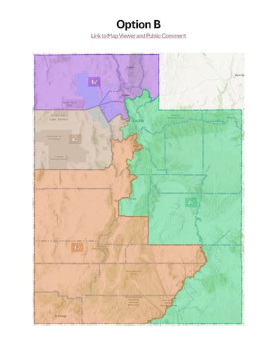
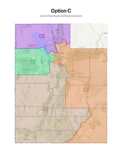
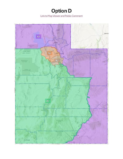
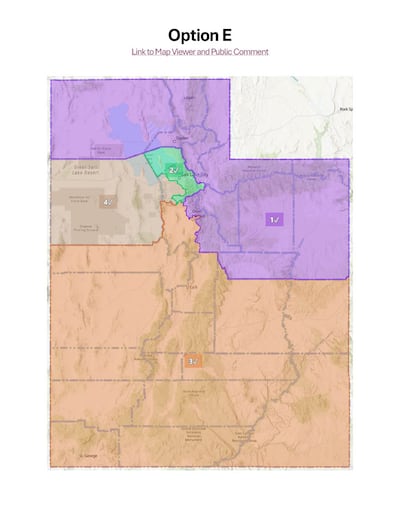
When the committee met on Monday, five maps were presented, all drawn by a Republican-hired consultant. On Wednesday, the Democrats presented a sixth option for consideration. Wednesday’s meeting which took place in the Senate Building on Capitol Hill, included more fiery debate about process and bias than the previous meeting did.

The meeting was led by committee chair Rep. Candice Pierucci, R-Herriman, who opened the meeting by saying “we are here using a redistricting process standards and requirements that were not chosen by the legislature, and we’re here pursuant to a court order.”
This map redrawing comes after a district court judge threw out Utah’s congressional maps following a lawsuit brought by proponents of Proposition 4, who say lawmakers did not follow the parameters set out in the proposition. Republican lawmakers say the state Constitution grants legislators the authority to draw congressional maps.
The debate over partisan bias

Minority Leader Sen. Luz Escamilla, D-Salt Lake City and Rep. Doug Owens, D-Millcreek, presented a sixth option to be considered by the committee.
During the presentation and the discussion period, there was very little discussion about the actual map. Most of the discussion revolved around the way partisan symmetry should be tested — which was debated on Monday — and discussing the credibility and methods of two experts who were brought in to help draw maps.
Owens and Escamilla were joined by an expert they had hired to help them draw their map, Daniel Magleby, an associate professor of political science and economics at Binghamton University. The expert who drew the other five maps is Sean Trende, an elections analyst at RealClearPolitics.

Magleby critiqued the methods used by Trende to analyze the partisan symmetry of the five maps he presented and analyzed. The method of how maps are tested was also debated on Monday, while lawmakers also debated the issue of partisan bias. They have been tasked with drawing maps void of partisan bias.
Rep. Calvin Roberts, R-Draper, called Magleby’s own bias into question by reading X posts from the professor which criticized the Legislature, specifically Republican lawmakers. In one of the posts he referred to the Legislature as “authoritarian.” Roberts said these posts read “like a left wing activist.”
On Monday, Trende was questioned by the Democrat members of the committee about his own partisan bias.
Magleby pointed out that he specifically did not analyze the map for bias until after it was created, which is what Prop 4 dictates. He added that if such analysis was done before a map was complete, that would be illegal.
“I’ll make one additional point, what he just described as being illegal, we strongly suspect has happened,” Owens said. He added that he wasn’t accusing anyone on the committee but rather Trende himself.
Under Prop 4, maps are required to be generated with no political partisan data, and then afterward be separately analyzed for partisan symmetry.
Owens and Escamilla’s map
The map that was presented by Owens and Escamilla was created by taking a map previously created by the Independent Redistricting Committee and adjusting it to follow Prop 4.
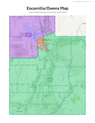
One of the standards of Prop 4 is minimizing the number of municipalities and counties that are split into different districts.

This map from Owens and Escamilla has 14 municipal splits and four county splits. This is significantly more than the other five maps which each have two or three municipal splits and between three and five county splits.
Owens and Escamilla’s map was critiqued by other members of the committee, specifically Rep. Stephanie Gricius, R-Eagle Mountain and Sen. Mike McKell, R-Spanish Fork.
Gricius pointed out the map does not just split neighborhoods, but streets and cul-de-sacs were split up into different districts.
McKell critiqued the number of cities and counties that were split by this map saying “to me, that was a failure of prop 4.”
He also added that one priority of Prop 4 is making districts geographically compact. He said that this map fails to do that.
When speaking about the other five maps Pierucci emphasized that each of them follow all seven standards required by Prop 4.
These maps were complimented by members of the committee for the way they respect geographical boundaries and mix together both rural and urban areas.
During the public comment period of the meeting some people said they believe all districts should have both rural and urban areas while others said these areas should be separated because they have such different interests.
What comes next?

Thursday is the start of the 10 day comment period for all of the maps that will be considered by the Legislature. If a map is not submitted by Thursday, then it cannot be considered by the Legislature.
After the 10 day comment period is over, on Oct. 6, the committee will meet and choose a map to recommend to the rest of the Legislature. Later that day a special session will be held to vote on the map.
The chosen map will then be submitted to Gibson who has to confirm a map by Nov. 10 so that preparations for the 2026 midterm election can begin.
“We value and want your input on the proposed maps,” Pierucci said, but added that they can’t consider any feedback pertaining to partisanship.
People can comment on any submitted maps — both from the committee and members of the public — at the committee’s website.
Why is the committee not using maps created by the IRC?
One question that was asked multiple times during Monday’s public comment period is why the committee isn’t using the maps that were drawn by the Independent Redistricting Committee in 2021.
Pierrucci shared that Gibson’s order said that those maps were are not allowable in this setting because the IRC was following SB200 and not Prop 4 when drawing the maps.