

There's a place in Big Cottonwood Canyon where you can watch the tides come and go — a billion years in the past.
Half a mile up City Creek Canyon from 11th Avenue, a concrete barrier braces the toe of an active landslide.
A massive limestone ridge is peppered with oceanic fossils, only 5.5 miles above the fee station near the mouth of Mill Creek Canyon. The fossils include shells and bits of coral from an ocean that washed Utah during the Triassic period, 248 million to 206 million years ago. At that time, on land, the earliest dinosaurs appeared.
These are only three of scores of geological features in the Salt Lake City area canyons, each with its own story. They are pinpointed and described in a fascinating new
booklet by the Utah Geological Survey, "Geologic Guide to the Central Wasatch Front Canyons: Salt Lake County, Utah." It's available for $3.95 at the Utah Department of Natural Resources Map & Bookstore, 1594 W. North Temple.
The 30-page booklet, with color photos and foldout maps, also can be ordered through the Internet, http://mapstore.utah.gov, or by contacting the store at 801-537-3320.
Accounts of roadside geology, with miles indicated from landmarks, cover the vehicle-accessible canyons: City Creek, Emigration, Parleys, Mill Creek, Big Cottonwood and Little Cottonwood.
"We'd actually been getting a lot of requests for such a comprehensive guide to the local canyons," said Sandy Eldredge, who worked on the project. "And up until now that has not been available in any form."
The project began about three years ago, with UGS geologists William F. Case handling Emigration, Parleys and Mill Creek; Mark R. Milligan, City Creek; Christine Wilkerson, Little Cottonwood; and Eldredge, Big Cottonwood.
"We each picked the canyons to do the field work and mileage and explain the geology," Eldredge said.
They took photos and researched topics of interest. Besides abundant geology references, the booklet points out some historic sites like a camping spot of the Donner Party in Emigration Canyon, the route of the pioneers of 1847, and drill bit marks for the quarry in Little Cottonwood where granite was mined for the Salt Lake LDS Temple.
But the focus is geology. These include the basics, she said, like "glaciers in the mountains, Lake Bonneville in the valley, the Wasatch Fault." The booklet also discusses earthquake faulting, periods of Earth history, comings and goings of oceans and rivers and Lake Bonneville, and varieties of rocks.
Some of the details are astonishing, like the Precambrian rock in Big Cottonwood Canyon. It is an exceptionally old formation, dating to between 800 million and 1 billion years ago. The canyon is dominated by Precambrian rock for its first six miles.
The booklet points out places where ripples of waves on ancient beaches are still visible (1.4 miles above Wasatch Boulevard) and mud cracks are preserved in this ancient formation (2.3 miles).
"You still have preserved ripple marks and mud cracks," Eldredge said. "It shows the daily and semi-daily ocean tides."
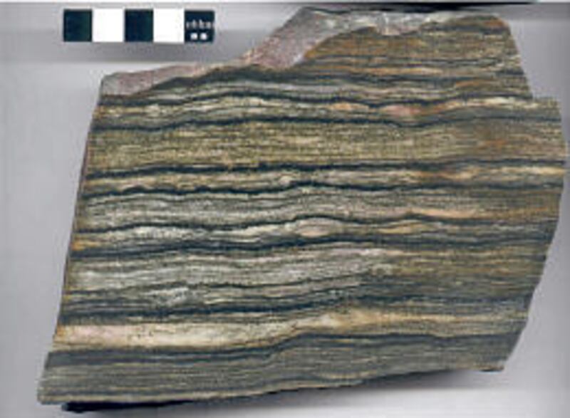
The Big Cottonwood Formation "tidal rhythmite" rocks are of world importance, with researchers studying them to learn about changes in the length of the day and the distance to the moon.
A close-up of the rock and information about it were provided by Marjorie A. Chan, professor and chairwoman of the University of Utah's department of geology and geophysics.
"In the Big Cottonwood Formation, which is right up Big Cottonwood Canyon, there are some shales and sandstones that everybody drives past on their way to the ski resorts," Chan told the Deseret Morning News. "Some of these have very fine rock layering."
Black and white layers are marks left by the twice-daily high and low tides. "It's so fine, it's sort of like counting tree rings," Chan said. The dark material is silt and clay while the white is sand from the ancient beach.
According to the guidebook, sand was carried in by peak flows, higher tides, while the silt and clay came with weaker waters at changing tides.
Thick layers indicate where the tides were especially high, which happens when the Earth, moon and sun line up. When the deposits are thin, the three spheres were least aligned.
Counting tide layers and using statistics, scientists showed that Earth, sun and moon were in the same orientation in the Precambrian as they are now. But some things were different.
Knowing the celestial geometry and calculating how many days passed between exceptionally high and low tides, scientists made surprising discoveries.
"You can actually calculate how many days were in a year and you can estimate how fast the Earth was rotating back in the Precambrian," she said. The year was closer to 400 days, "and the Earth was spinning faster."
Days were only about 18 hours long. In the eons since the layers were preserved, Chan said, "the tides have actually probably slowed down the rotation of the Earth."
E-mail: bau@desnews.com