
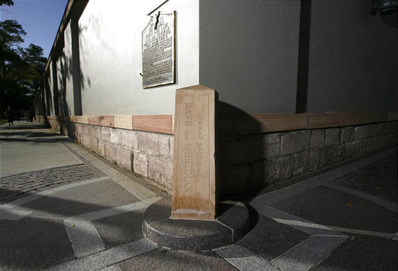


Almost every piece of property in Utah has a connection to a small obelisk-shaped monument on the southeast corner of Temple Square.
"When you think of all the different kinds of sculptures and monuments around the city, this is probably the smallest and the least visually impressive," said Richard Oman, curator of acquisitions at the Museum of Church History and Art. "But ... this is the real thing."
What impresses Oman is not the size of the monument, but what it stands for both literally and symbolically. The "Great Salt Lake Base and Meridian" stone has ties to the earth and to the temple.
"They didn't begin laying out the city until Brigham Young had identified that 'Here we will build the temple.' Once they had identified where ... the temple was going to be, then they could begin laying out the city," Oman said.
Surveying land requires a beginning point. On Aug. 3, 1847, less than two weeks after entering the valley, Orson Pratt chose a point to be the southeast corner of the new temple block.
That point would be used to survey the temple block and the fledgling city. Everything measured back to the intersection of that baseline (the East/West or latitude line) and meridian (the North/South or longitude line). Oman believes it was probably the earliest base meridian in the western United States.
"As soon as the Mormons got here, they promptly organized the space. They promptly brought structure and order to their environment," Oman said. "And that is a tangible expression of a mind-set ... if Mormons are anything, they are structured and organized."
When David H. Burr came eight years later as Utah's first surveyor-general, he wrote, "I have established the initial point for the survey of this valley at the S.E. corner of the Temple Block, in the center of this city, and am having a stone cut to place at the spot for a monument."
This act by a federal official validated Orson Pratt's point as the recognized base and meridian. An expense voucher states that "the sum of twenty-five dollars was paid to Benjamin Thomas Mitchell for making stone for the Meridian Mark." According to "Initial Points of the Rectangular Survey System" by C. Albert White, the initial point for public land surveys was officially established on Aug. 6, 1855, and the stone was installed in October 1855.
Brent Tidwell, chief deputy surveyor for Salt Lake County, explained that every state has an initial point where all surveys for the state are located. All property descriptions refer to points that link back to the Base Meridian stone.
"We tie all our surveys to the Base Meridian. That's a fairly significant monument that exists right there," Tidwell said.
For Oman, some of that significance comes from the temple — that even giving someone your address, in Salt Lake, acknowledges the location of the temple.
"What it does is it makes the temple literally the center of our lives, not only as Latter-day Saints, and not only for Temple Square, but it makes the temple literally the center of our lives even for the legal identification of our property lines of our lots and our streets," Oman said.
Time took its toll on the sandstone pillar. Horse-drawn snowplows were used to move snow from the sidewalks. Frequently they struck the monument and chipped it. In 1932 an iron fence was put around the Base Meridian stone and a commemorative plaque was placed on the wall next to it. Unveiling honors went to Orson Pratt's oldest living daughter, Lathilla Pratt Kimball.
Concerns about the deterioration of the marker arose again in the 1950s, but it wasn't until Aug. 17, 1989, that something was done. A sandstone replica was carved by Johann "Hans" Huettlinger, a master stonecutter, and carefully placed in the same location.
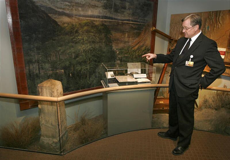
The original stone found a home in the Museum of Church History and Art, where Oman works.
He explained that the word "temple" comes from putting together two words. The first part of the word refers to "template," or the organizing of horizontal space. The second part comes from the root word for "plumb" — as in a surveyor's plumb line — and refers to the organizing of vertical space.
"So (the) temple is literally the connection between heaven and earth. And that is why the Baseline Meridian stone, being on Temple Square, and everything being measured from the temple is so theologically and historically perfect — because it really does bring the connection between heaven and earth," Oman said. "And when it gets down to earth it literally organizes the space."
An even lesser-known stone monument is about 100 feet north and 50 feet west of the Base Meridian stone. Just to the north of the South Visitors Center is the replica of the red sandstone observatory stone. This "U"-shaped stone was a telescope base for an observatory built in 1869.
That observatory was part of a series of similar government observatories across the country that were used to establish local time — and, according to Oman, to verify longitude readings. According to White's book, the observatory was used to regulate the city's clocks until the end of 1897. Land surveys continued to be tied to the Base Meridian stone.
"The Base Meridian stone establishes the horizontal relationships that we have in a city, and it ties all our mapping back to the temple," Oman said. "It seems wonderfully poetic that we had an observatory on Temple Square that ties us here on earth and then links us up to into the heavens through a telescope."
Oman takes delight in the unobtrusive simplicity of the Base Meridian stone:
"It reminds me of an Indiana Jones movie. You remember that movie, the search for the Holy Grail? They have all of these fancy grails, cups. But the real one was the real humble one. Well, that's kind of like this monument. It's small and humble, but absolutely central."
E-mail: mdegroote@desnews.com
MERIDIANMARKER