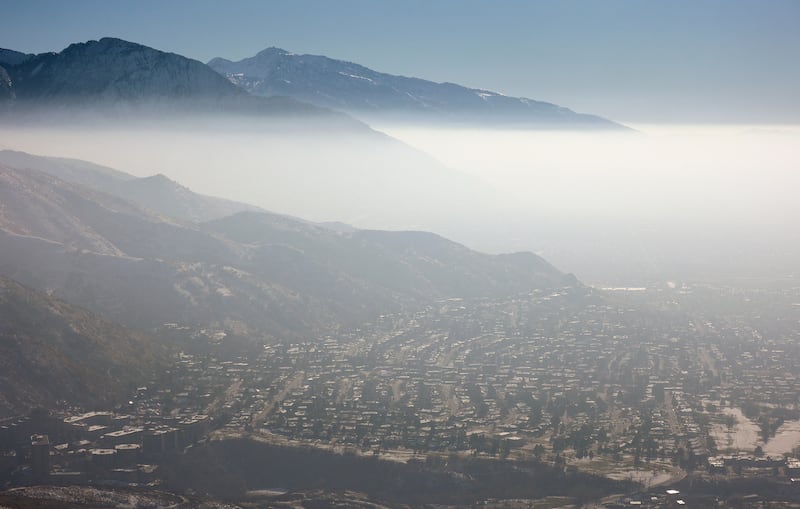
An inversion formed after Utah’s latest storm wave, and it didn’t take long for air quality to plummet across the Wasatch Front.
Several Salt Lake Valley cities led the nation in poor air quality on Monday, as air quality index scores dropped to levels considered unhealthy for sensitive groups, according to IQAir’s monitor network.
Air quality is projected to be unhealthy for sensitive groups in Salt Lake County on Tuesday, while remaining “moderate” across the rest of the Wasatch Front, Tooele and northern Utah regions, according to the Utah Division of Air Quality. Davis and Utah counties are forecast to join Salt Lake in the “orange” range by Wednesday.
The agency ordered mandatory actions across the region this week, prohibiting open burning and solid-fuel-burning devices. Residents are also urged to consolidate trips to reduce vehicle emissions.
What is an inversion?
All of it comes from the inversion, which develops when warm air forms over cold air in the valley, trapping the cold in place and any water vapor and emissions below. This typically occurs when there’s a lull in storm activity.
This wonky setup is why Salt Lake City’s high was only 40 degrees on Monday, while it reached 48 degrees at one of the National Weather Service’s Alta sites, a few thousand feet higher in elevation.
Patchy fog from water vapor is possible over the next few nights, depending on the conditions, which could add to visibility challenges, says KSL meteorlogist Matt Johnson.
How long will it last?
The trend is expected to continue for most of the rest of the workweek, as a large high-pressure system lingers over California, blocking storms from entering the state.
There’s a chance for relief from a storm system projected to move across the Great Lakes region later this week, Johnson said. While the storm itself won’t produce any moisture in Utah, stronger winds from a shallow cool front behind the system could reach the state, and potentially break up the inversion.
Air quality will continue to decrease along the Wasatch Front through at least late in the week as valley inversions remain in place. What can you do to help protect yourself and reduce pollution? #utwx pic.twitter.com/VRRtPmpLaV
— NWS Salt Lake City (@NWSSaltLakeCity) January 12, 2026
If not, the inversion — and the haze below it — will likely continue into the weekend and into the start of next week. Most of Utah has slightly higher odds for moisture toward the end of next week, per a National Weather Service Climate Prediction Center long-range forecast issued on Monday. It signals a potential return of storms then.
For now, the weather service advises avoiding as much travel as possible by teleworking if possible, or using public transit to reduce inversion pollution. It also recommends that people stay inside as much as possible or wear a mask with a filter blocking out particulate matter 2.5.
Full seven-day forecasts for areas across Utah can be found online at the KSL Weather Center.


