
Utahns expect January to be cold, but Sunday the cold came as record-breaking lows at night and record icy highs during the day. Still, Utahns can be grateful they don't live in the Midwest or East.
Utah has been slammed with a river of cold air. "It wasn't straight from the North Pole," said KSL meteorologist Dan Pope, "but it was straight out of Canada."
Howling in from that country's frigid Northwest Territories, the cold air mass followed the jet stream as it jogged southward over Utah. And, as Pope points out, "This is the coldest time of the year."
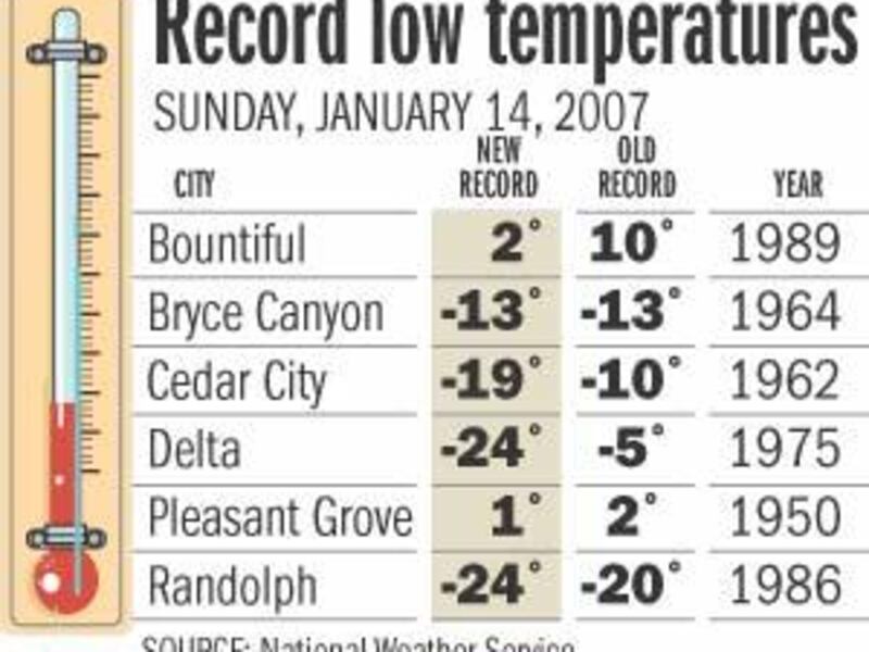
In widely scattered sections of Utah, the National Weather Service recorded a dozen records for the coldest Jan. 14 and another three frosty temps that tied the previous lows. Delta residents shivered in a nearly unbelievable minus 24 degrees, as did those of Randolph, Rich County. It was 19 below zero at the Cedar City Airport and minus-23 in Richfield.
"Highs" of the day also were at record low levels, or tied for the record, at Brian Head, Bryce Canyon, Cedar City, Coalville, Delta, Duchesne, Fillmore, Kanab, Nephi, Pleasant Grove, Provo at Brigham Young University, Richfield, Spanish Fork, Tooele, Utah Test and Training Range, and Wendover. The coldest highs were 9 degrees, at Duchesne and Richfield.
Freezing conditions hit the entire state, with Salt Lake City's low Sunday registering minus 1 degree with a high temperature of only 18. In St. George, the low and high were 14 and 32; Logan, minus 9 and 13; Provo, zero and 15.
According to KSL meteorologist Dina Freedman, today's forecast calls for: Salt Lake City, minus 1 as a low, 18 as the high; St. George, 15 and 34; Ogden, zero and 18; Logan, minus 10 and 11; Provo, minus 2 and 17.
Freedman and Pope said today should be "mostly sunny to sunny statewide, with increasing pollution in northern Utah." Haze was expected build up as an inversion trapped colder weather and blocked the escape of pollutants.
Stagnant air should begin to accumulate significantly around the middle of the week, Pope said. Meanwhile, Utah will be locked in a deep freeze until clouds and winds arrive.
Temperatures throughout much of the state this week should range from 10 degrees to 18 degrees below normal.
Still, compared with other parts of the country, that will be a cakewalk, if a chilly one. In the Midwest and East, ice storms were blamed for at least 20 deaths, and power was knocked out for hundreds of thousands of people.
Waves of freezing rain, sleet and snow since Friday have caused at least 11 deaths in Oklahoma, six in Missouri, two in Texas and one in New York.
Seven adults were killed early Sunday near Elk City, Okla., when the minivan they were in hit a slick spot on I-40, crossed the median and hit a semitrailer truck, the Oklahoma Highway Patrol reported.
Missouri Gov. Matt Blunt said about 300,000 households there remained without power on Sunday. About 350 National Guardsmen were going door to door checking on residents in the hardest-hit areas and were helping to clear slick roads of tree limbs and power lines.
"We have what appears to be a three-wave storm," he said. "We're in the final wave of it."
About 111,000 customers lacked power in Oklahoma, utilities reported. In Texas, 415 flights were canceled Sunday at Dallas-Fort Worth International Airport.
In Nebraska, which has been pummeled by winter storms over the past month, the weekend storm dropped even more snow, making roads treacherous.
As the storm began to fade from the nation's midsection, parts of the East began to suffer.
In Albany, N.Y., a 22-year-old man fell about 90 feet from a bridge to a road below after climbing a railing to avoid being hit by a sliding car. He had gotten out of his vehicle about 2 a.m. after a crash.
In Syracuse, N.Y., I-81 was closed for about two hours after about 30 cars were involved in six accidents early Sunday. Several people were taken to hospitals.
E-mail: bau@desnews.com